We Get Around NetworkForms
Browse FormsPricingAbout
Sign inGet started
We Get Around Network

WGAN Forms

A library of business, legal, and operational templates built for real estate photographers, Matterport service providers, 3D capture specialists, and proptech professionals.

A product of We Get Around Network — the largest global community for real estate photographers and 3D capture pros.

Library

  • Browse forms
  • Pricing
  • Redeem promo code

Company

  • About
  • We Get Around Network
  • Legal disclaimer
  • Terms
  • Privacy

Disclaimer: All forms provided are templates for informational purposes only and do not constitute legal advice. Consult a qualified attorney before using any agreement in your business.

© 2026 We Get Around Network. All rights reserved.

Back to library
3D Capture & Virtual Tours

Digital Twin Deliverable Specification

A deliverable specification template for digital-twin projects defining point-cloud density, export formats, accuracy tolerances, turnaround times, and post-delivery revision windows for real estate scanning professionals.

Last updated Jul 7, 2026

Disclaimer: This template is for informational purposes only and is not legal advice. Have a qualified attorney review it before use.

What is the Digital Twin Deliverable Specification?

The Digital Twin Deliverable Specification is a structured project agreement template for real estate scanning professionals that locks in every technical requirement before capture begins. It defines point-cloud density, scan station intervals, RMS registration error thresholds, absolute positional accuracy tolerances, export file formats, turnaround timelines, revision windows, and intellectual property terms between a Provider and Client for a specific property address.

When should you use this form?

The Digital Twin Deliverable Specification is appropriate whenever a real estate photographer, LiDAR operator, or 3D tour creator is hired to deliver spatial data files — such as RVT, IFC, LAS/LAZ, E57, or OBJ — to an architect, developer, property manager, or construction firm. Use it before scanning begins on any project where accuracy tolerances, file format requirements, or rush-delivery terms need to be documented and agreed upon in writing.
What's included in this template?

  • Acceptance and scope clause identifying Provider, Client, and property address
  • Capture methodology section specifying point-cloud density and scan station intervals
  • Accuracy tolerances with ±2 cm architectural-grade positional accuracy standard
  • Export format list covering RVT, IFC, OBJ, LAS/LAZ, E57, and hosted tour links
  • Turnaround and delivery schedule with standard and rush-delivery surcharge terms
  • Post-delivery revision window with one included round and hourly rate for additional rounds
  • Intellectual property and license terms for delivered spatial data
  • Governing law, dispute resolution, and limitation of liability clauses

How do I fill out this form?

  1. Open the form at forms.wgan.info. Navigate to the Digital Twin Deliverable Specification page on forms.wgan.info and click the form to open the online editor in your browser.
  2. Enter project and party details. Fill in the effective date, Provider legal name, Client legal name, and the full property address in the designated fields at the top of the form.
  3. Set capture and accuracy parameters. Input your point-cloud density in pts/m², maximum scan station interval in meters, target RMS registration error in millimeters, and absolute positional accuracy tolerance.
  4. Configure deliverables and timeline fields. Select the required export formats, specify standard delivery days, set rush-delivery threshold and surcharge amount, and enter the review period and revision hourly rate.
  5. Review all completed fields. Scroll through every section — from Capture Methodology through Governing Law — to confirm all bracketed placeholders have been replaced with accurate project-specific values.
  6. Download and distribute the finished document. Click the download button to save the completed specification as a PDF or editable file, then share it with the Client for review and signature before capture begins.

Preview

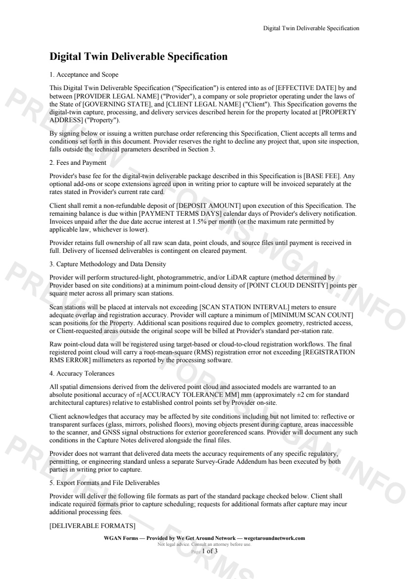
Digital Twin Deliverable Specification — page 1 preview covering Acceptance and Scope, Fees and Payment, Capture Methodology and Data Density
Page 1
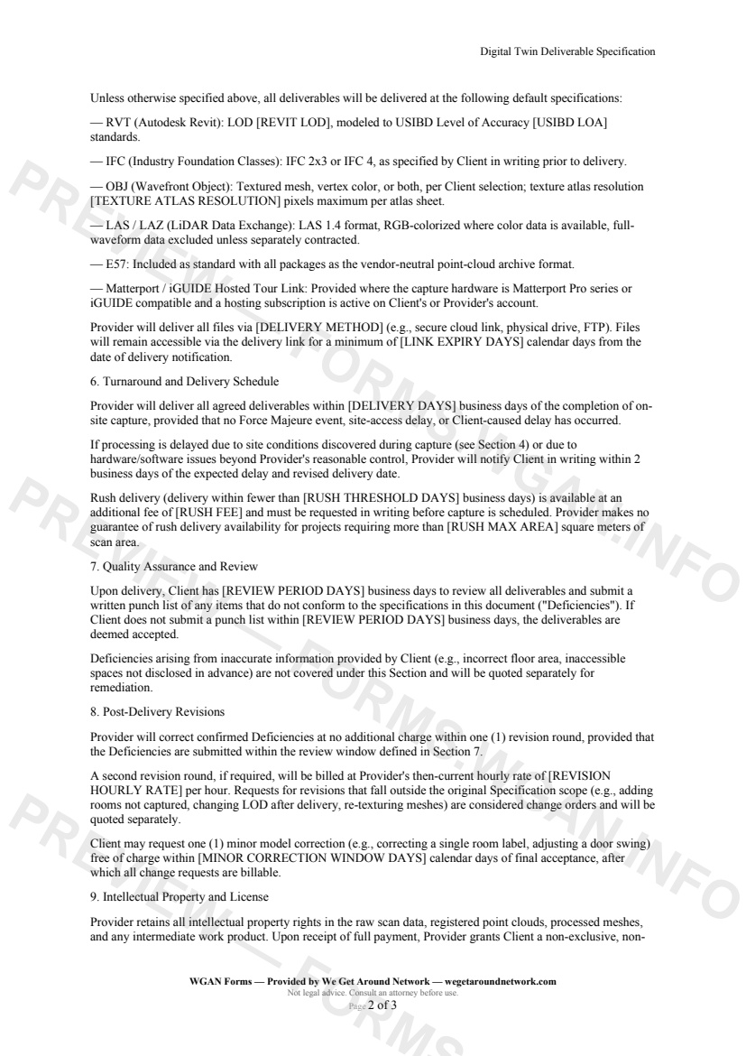
Digital Twin Deliverable Specification — page 2 preview covering Quality Assurance and Review, Post-Delivery Revisions, Intellectual Property and License
Page 2

First 2 pages shown — watermarked. Subscribe to fill out and download the unbranded document.

What this form covers

Acceptance and Scope

This Specification is entered into as of **[EFFECTIVE DATE]** by **[PROVIDER LEGAL NAME]** ("Provider") and **[CLIENT LEGAL NAME]** ("Client") for the property at **[PROPERTY ADDRESS]**. It governs all digital-twin capture, processing, and delivery work — locking in every technical requirement before a single scan is taken.

Capture Methodology and Data Density

Provider performs structured-light, photogrammetric, and/or LiDAR capture at a minimum point-cloud density of **[POINT CLOUD DENSITY] pts/m²**, with scan stations placed no more than **[SCAN STATION INTERVAL] m** apart. The final registered point cloud must achieve an RMS registration error of **≤ [REGISTRATION RMS ERROR] mm**.

Accuracy Tolerances

All delivered spatial data is warranted to an absolute positional accuracy of **± [ACCURACY TOLERANCE MM] mm** (the ±2 cm standard for architectural-grade capture). Provider documents any accuracy-limiting site conditions — reflective surfaces, restricted access, GNSS obstructions — in Capture Notes delivered alongside final files.

Export Formats and File Deliverables

The template covers every major format in the digital-twin ecosystem:

  • **RVT** — Autodesk Revit at a specified LOD and USIBD Level of Accuracy - **IFC** — IFC 2x3 or IFC 4 for open BIM workflows - **OBJ** — Textured mesh with configurable texture atlas resolution - **LAS / LAZ** — RGB-colorized LiDAR exchange files (LAS 1.4) - **E57** — Vendor-neutral point-cloud archive included as standard - **Hosted Tour Link** — Matterport / iGUIDE links where applicable

Turnaround and Delivery Schedule

Standard delivery is **[DELIVERY DAYS] business days** from capture. Rush delivery (under **[RUSH THRESHOLD DAYS] business days**) is available for a **[RUSH FEE]** surcharge, subject to project-size limits.

Post-Delivery Revisions

Client has **[REVIEW PERIOD DAYS] business days** to submit a punch list. One full revision round is included at no charge. A second round is billed at **[REVISION HOURLY RATE]/hr**, keeping scope creep firmly in check.

Table of contents

  1. Acceptance and Scope
  2. Fees and Payment
  3. Capture Methodology and Data Density
  4. Accuracy Tolerances
  5. Export Formats and File Deliverables
  6. Turnaround and Delivery Schedule
  7. Quality Assurance and Review
  8. Post-Delivery Revisions
  9. Intellectual Property and License
  10. Limitation of Liability
  11. Governing Law and Dispute Resolution
  12. Entire Agreement and Amendments

What's included

  • Point-cloud density and scan station interval requirements
  • Absolute positional accuracy tolerances (±2 cm typical)
  • Export format specs: RVT, IFC, OBJ, LAS/LAZ, and E57
  • Revit LOD and USIBD Level of Accuracy declarations
  • Standard and rush turnaround timelines with surcharge terms
  • Structured client review window and punch-list process
  • Two-round revision policy with hourly rate for extras
  • IP ownership, licensing, and resale restrictions
  • Limitation of liability and binding arbitration clause
  • Customizable placeholders for every key data point
#digital-twin#deliverable#point-cloud#specification

Fill out this form

Subscribers only

Subscribe at $19/mo (or $149/yr) to fill any form online and download the completed PDF unlimited.

Sign in to subscribeSee pricing

Related forms in 3D Capture & Virtual Tours

Other templates capture pros use alongside this one.

See all in 3D Capture & Virtual Tours →
3D Capture & Virtual Tours

Hosting Subscription Handoff Agreement

A structured agreement for real estate photographers and 3D tour providers to formally transfer Matterport, iGUIDE, or similar tour hosting from the photographer's account to the client's account.

#hosting#handoff#subscription
View form
3D Capture & Virtual Tours

Matterport Scanning Agreement

A Matterport-specific 3D scanning services agreement for real estate photographers covering Pro3/Pro2 capture, tour hosting, embed rights, and tour lifecycle management.

#matterport#3d-tour#scanning
View form
3D Capture & Virtual Tours

Tour Ownership Transfer Form

A legally structured transfer form for reassigning a 3D virtual tour to a new listing agent, brokerage, or property owner — covering acknowledgment, acceptance, and hosting-account updates.

#ownership#transfer#tour
View form
3D Capture & Virtual Tours

iGUIDE Capture Agreement

A client-ready iGUIDE capture services agreement for 3D scanning providers covering floor plans, GLA verification, Planitar hosting, MLS licensing, and add-on services.

#iguide#floor-plan#3d-tour
View form