We Get Around NetworkForms
Browse FormsPricingAbout
Sign inGet started
We Get Around Network

WGAN Forms

A library of business, legal, and operational templates built for real estate photographers, Matterport service providers, 3D capture specialists, and proptech professionals.

A product of We Get Around Network — the largest global community for real estate photographers and 3D capture pros.

Library

  • Browse forms
  • Pricing
  • Redeem promo code

Company

  • About
  • We Get Around Network
  • Legal disclaimer
  • Terms
  • Privacy

Disclaimer: All forms provided are templates for informational purposes only and do not constitute legal advice. Consult a qualified attorney before using any agreement in your business.

© 2026 We Get Around Network. All rights reserved.

Back to library
Drone & Aerial Operations

No Fly Restricted Area Disclosure

A drone-operator disclosure form identifying no-fly zones, TFRs, and restricted airspace that affect a shoot, with proposed alternatives for real estate and proptech clients.

Last updated Jul 7, 2026

Disclaimer: This template is for informational purposes only and is not legal advice. Have a qualified attorney review it before use.

What is the No Fly Restricted Area Disclosure?

The No Fly Restricted Area Disclosure is a pre-shoot document issued by a licensed FAA Part 107 drone operator to a real estate or proptech client when airspace research reveals a legal flight restriction at the subject property. It records the restriction type and authority, documents the impact on the contracted aerial scope, proposes lawful alternatives, and captures the client's formal election on how to proceed. The form creates a timestamped, signed record protecting both parties before any flight is attempted.

When should you use this form?

The No Fly Restricted Area Disclosure should be used any time pre-flight airspace research uncovers a TFR, Class B/C/D airspace boundary, National Park or stadium no-fly zone, Department of Defense restriction, or local municipal ordinance that prevents or limits the aerial services originally contracted. It is also appropriate when an authorization request is pending or has been denied and the operator needs a documented client election before rescheduling or substituting ground-based alternatives.
What's included in this template?

  • Parties and property identification with operator Part 107 credentials
  • Identified airspace restriction type, authority, and authorization status
  • Impact on shoot scope with affected property percentage
  • Proposed alternatives including ground-based, perimeter, and virtual tour options
  • Original contracted fee, adjusted fee, and non-refundable deposit terms
  • Waiver and FAA authorization filing process documentation
  • Client acknowledgment and formal election of preferred course of action
  • Governing law, dispute resolution, and entire agreement clause

How do I fill out this form?

  1. Open the form at forms.wgan.info. Navigate to forms.wgan.info and locate the No Fly Restricted Area Disclosure template in the drone operator or real estate photography category to begin a new session.
  2. Enter parties and property details. Fill in the operator's Part 107 credentials, the client's name and contact information, and the full address of the subject property where the restriction was identified.
  3. Document the airspace restriction. Select the restriction type from the provided options, enter the applicable authority such as FAA or National Park Service, and record the current authorization status and any request reference numbers.
  4. Specify shoot impact and proposed alternatives. Describe which aerial services cannot be performed, estimate the affected property percentage, and select or describe the alternative delivery options being offered to the client.
  5. Set fees and cancellation terms. Enter the original contracted fee, the adjusted fee for accepted alternatives, the non-refundable deposit amount retained for pre-flight research, and any rescheduling hold fee.
  6. Generate, download, and deliver the disclosure. Review all entries for accuracy, generate the completed disclosure document, download the PDF, and deliver it to the client for signature before any further shoot activity occurs.

Preview

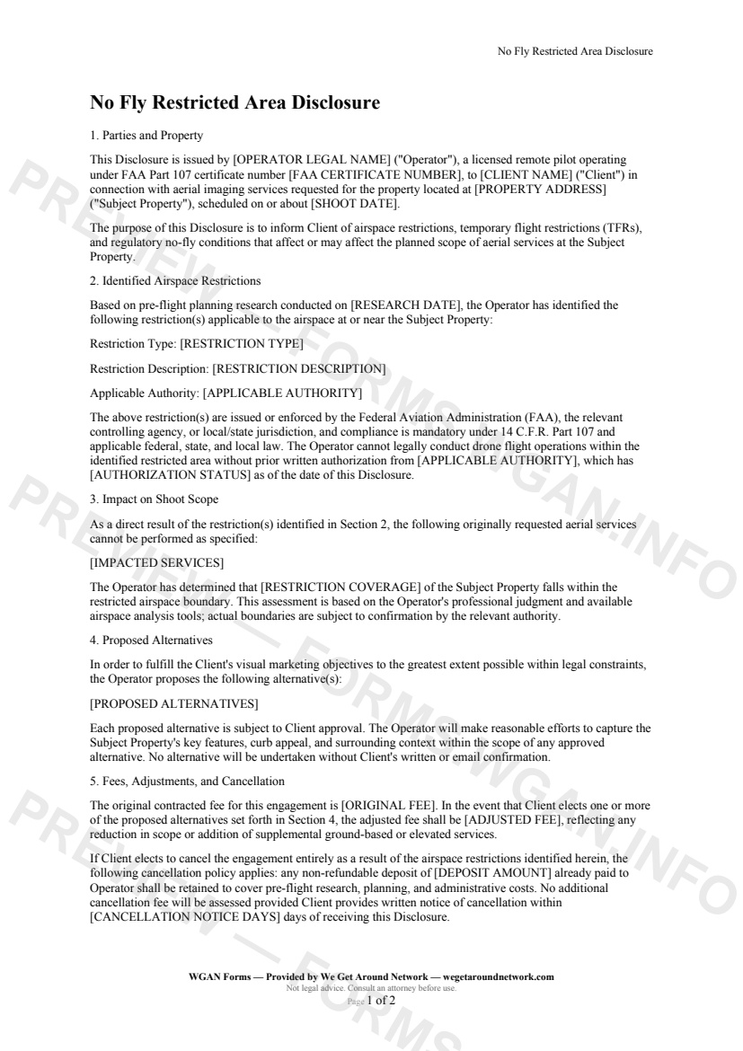
No Fly Restricted Area Disclosure — page 1 preview covering Parties and Property, Identified Airspace Restrictions, Impact on Shoot Scope
Page 1
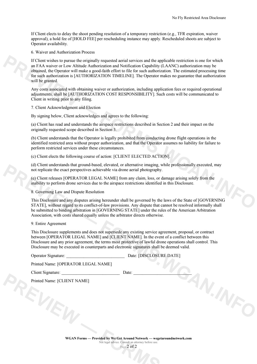
No Fly Restricted Area Disclosure — page 2 preview covering Waiver and Authorization Process, Client Acknowledgment and Election, Governing Law and Dispute Resolution
Page 2

First 2 pages shown — watermarked. Subscribe to fill out and download the unbranded document.

What this form covers

Parties and Property

This Disclosure is issued by your licensed Part 107 drone operator to the Client in connection with aerial imaging services at the Subject Property. It formally documents the pre-flight airspace research conducted and ensures all parties understand legal flight limitations before work begins.

Identified Airspace Restrictions

Before every flight, operators are required to assess the airspace. This section captures exactly what was found — including the **restriction type** (TFR, Class B/C/D airspace, National Park boundary, stadium no-fly zone, or municipal ordinance), a plain-language **restriction description**, and the **applicable authority** (FAA, National Park Service, Department of Defense, etc.).

It also records whether authorization has been requested, is pending, or has been denied — giving both parties a clear, timestamped record.

Impact on Shoot Scope

Not all restrictions ground the entire shoot. This section specifies:

  • Which originally requested aerial services **cannot be performed** - What percentage or portion of the property falls within the restricted boundary - The professional basis for that assessment

Proposed Alternatives

Rather than simply saying "we can't fly," this form documents constructive alternatives the operator has developed, which may include:

  • **Ground-based elevated photography** (ladder, pole, or crane shots) - **Perimeter aerials** from outside the restricted boundary - **Weather-delayed or TFR-expiration rescheduling** - **Virtual tour enhancements** to supplement missing aerial angles

Fees, Adjustments, and Cancellation

Fees are handled transparently. The form records the original contracted fee, the adjusted fee if alternatives are accepted, and a clearly stated non-refundable deposit retained for pre-flight research costs if the Client cancels. A per-instance rescheduling hold fee can also be specified.

Client Acknowledgment and Election

The Client formally selects their preferred course of action — accepting alternatives, canceling, delaying for a waiver, or proceeding with an authorization filing — and releases the operator from liability arising solely from the legal flight restriction.

Table of contents

  1. Parties and Property
  2. Identified Airspace Restrictions
  3. Impact on Shoot Scope
  4. Proposed Alternatives
  5. Fees, Adjustments, and Cancellation
  6. Waiver and Authorization Process
  7. Client Acknowledgment and Election
  8. Governing Law and Dispute Resolution
  9. Entire Agreement

What's included

  • Identifies TFRs, controlled airspace, national parks, and stadium no-fly zones
  • Documents the specific restriction type, authority, and NOTAM details
  • Describes impacted aerial services and restricted airspace coverage
  • Offers structured alternatives: ground-based, elevated, or rescheduled shoots
  • Provides fee adjustment and non-refundable deposit terms
  • Covers FAA waiver and LAANC authorization process and cost responsibility
  • Includes client election of action with clear options
  • Legally binding client acknowledgment and release clause
  • Governed by operator's state law with arbitration clause
#no-fly#restricted#faa-part-107#disclosure

Fill out this form

Subscribers only

Subscribe at $19/mo (or $149/yr) to fill any form online and download the completed PDF unlimited.

Sign in to subscribeSee pricing

Related forms in Drone & Aerial Operations

Other templates capture pros use alongside this one.

See all in Drone & Aerial Operations →
Drone & Aerial Operations

Aerial Services Scope Addendum

Aerial Services Scope Addendum — WGAN 2026 form template.

View form
Drone & Aerial Operations

Post-Flight Checklist & Flight Log

Post-Flight Checklist & Flight Log — WGAN 2026 form template.

View form
Drone & Aerial Operations

Drone Incident Report

A structured incident/near-miss report for drone operators documenting events, contributing factors, damage, injuries, witness statements, corrective actions, and FAA Part 107.9 reporting compliance.

#drone#incident#report
View form
Drone & Aerial Operations

FAA Part 107 Pre-Flight Checklist

FAA Part 107 Pre-Flight Checklist — WGAN 2026 form template.
View form